 |
|
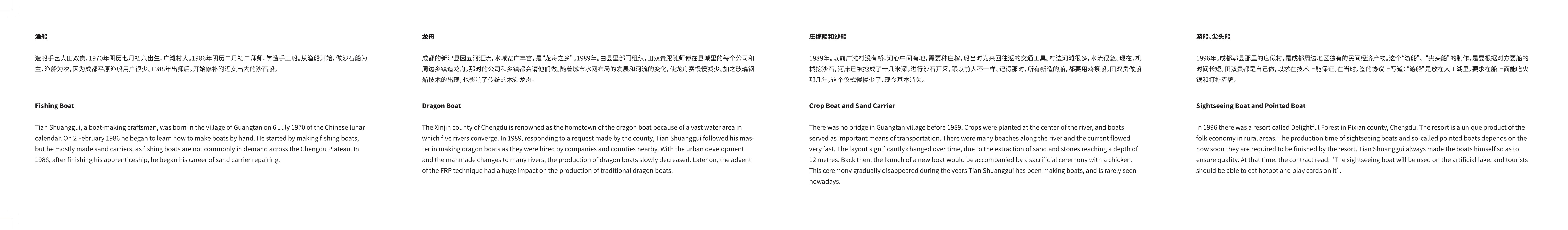
"Water System Refuge" (Upper Minjiang River, Qiang Dazhaizi, Sichuan, China) |
|
|
|
"Water System Refuge" (Upper Minjiang River, Qiang Dazhaizi, Sichuan, China) |
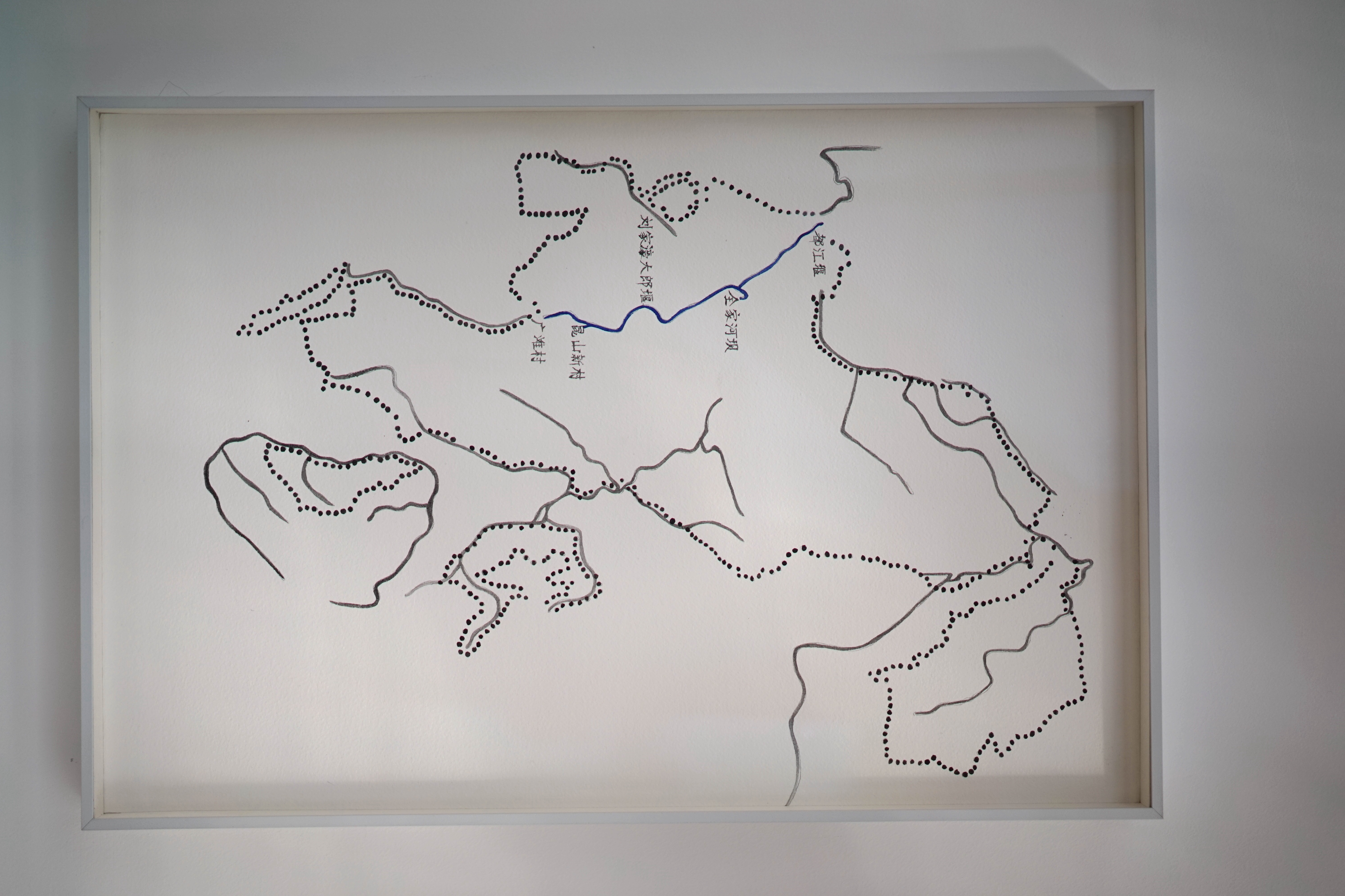
"The source of the Minjiang River lies in the Songpan Plateau, in the Min Mountains of the eastern Qinghai-Tibet Plateau. From its source to Dujiangyan, it is upstream of the Minjiang River. In this section, the Minjiang River passes through the Min Mountains, Qionglai Mountains, and Longmen Mountains of the Hengduan Mountains of the eastern Qinghai-Tibet Plateau, forming a topography of steep mountains and valleys. This is a place where the Qiang and Tibetans live together, and historically it is also a place where the ancient Qiang groups thrived." "The Minjiang River flows from Dujiang Weir (also named Dujiangyan) out of the Longmen Mountains to the Chengdu Plain, and then to Leshan, which is the midstream of the Minjiang River. The Minjiang River has also changed from a subtle convergent water system in the canyon to a radial fan-shaped river system and an alluvial plain. This plain is the largest in southwest China with an area of about 9,000 square kilometers. Unlike the lowland plains formed downstream of some large rivers, the Chengdu Plain is between 450 and 750 meters above sea level. It is a high-level sloping plain on a tributary of the upper Yangtze River. The ancients took advantage of the topographic difference of the high point of the river bed where the Minjiang River exits Longmen Mountain and the plain in front of the mountain, to create the Dujiangyan Irrigation Project for artesian irrigation, which laid the foundation for the land of plenty of "Rain and drought can be adjusted according to people’s wishes, so the people there don’t know what hunger is." "From Leshan to Yibin, it is downstream of the Minjiang River. The Minjiang River merged into the Jinsha River in Yibin. After the Jinsha River merged with the Minjiang River, it began to be called the Yangtze River.” This is the geologist Fan Xiao’s narrative from a geological perspective in his article "The Minjiang River Flowing from the Plateau to the Land of Plenty".
 |
|
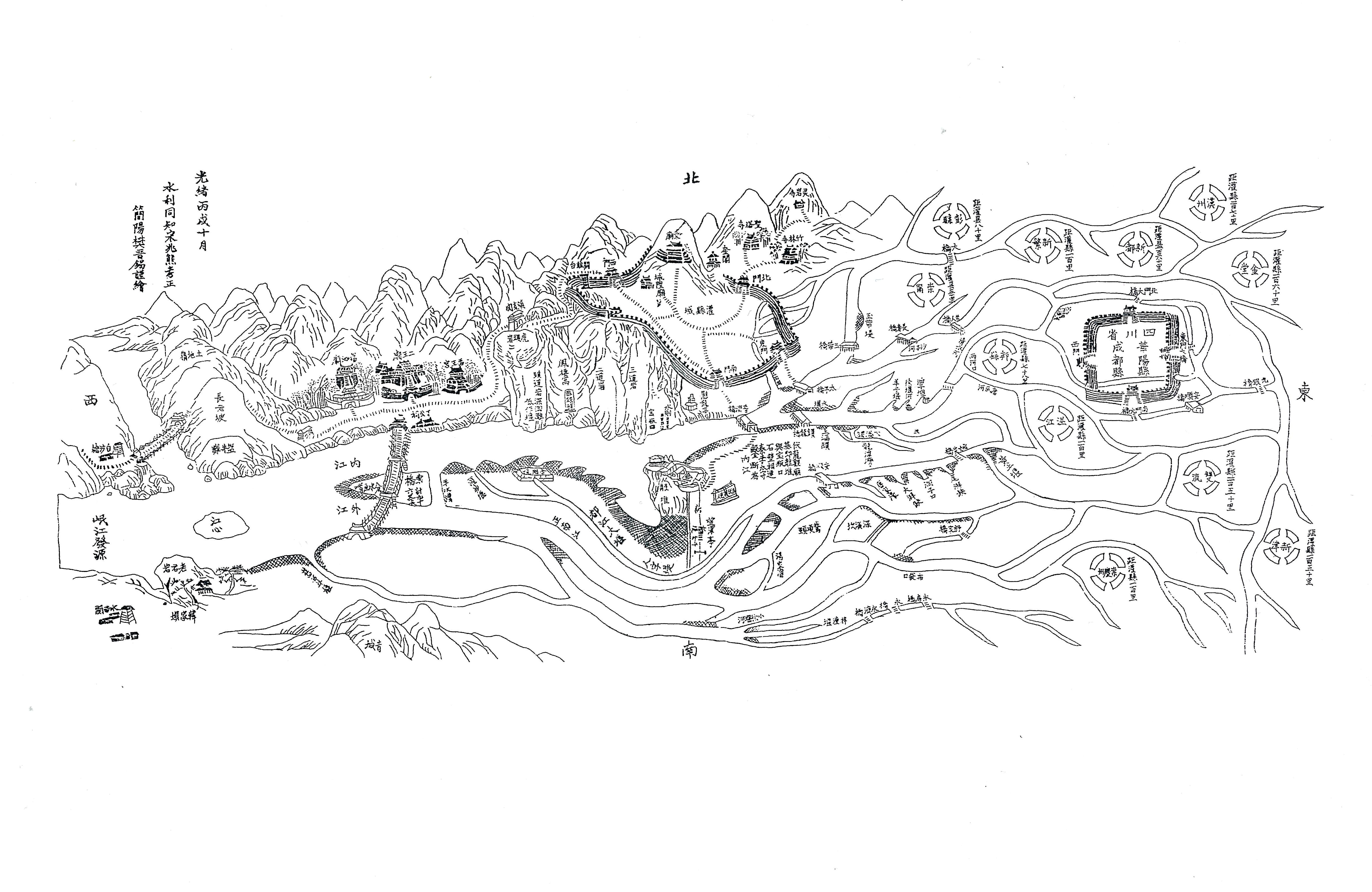
Distribution map, photo paper, late Qing Dynasty |
"Artists Cao Minghao and Chen Jianjun currently live and work in Chengdu, China. Cao Minghao was born in Changchun, China in 1982, studied at Jilin University of Arts and Southwest Minzu University and obtained a master's degree in art design in 2018. Chen Jianjun was born in Nanyang, China in 1981, studied at Jilin University of Arts and obtained a Bachelor of Arts degree in 2006.
Artists Cao Minghao and Chen Jianjun initiated the "Water System Project'' in 2015, which is based on art practice and research based on the Dujiangyan Irrigation Project. Dujiangyan is located between the mountains and plains of the Minjiang River in Sichuan. It is a water conservancy project that is still in use, with a history of more than 2,260 years. Dujiangyan was built in 256 BC. It was built with the help of mountains and water. It is the world's oldest water diversion project without a dam, and it is still in use today. After the Minjiang River flows to the irrigation head of the Dujiangyan, it is divided into two. The inner stream system on the east side enters the water conveyance system of the Chengdu Plain, and the outer stream serves as a flood control and sediment discharge. After 1949, to increase the water diversion and irrigation area of the inner stream, they established outer stream gates, reservoirs, and other means. Since then, the manual adjustment has gradually become the dominant approach of the Dujiangyan Project. "Water System Project” uses the history of the Dujiangyan Irrigation Project and the current status of the upstream and downstream water systems as an entry point for art creation, and pays attention to the performance of water in people's life consciousness and related ecological practices, and artistically conducts research on ecological politics. The vast area covered by the water system, and the rich topics and networks brought by many years of practice have made the "Water System Project" an action space for artists to continue to explore in different kinds of interdisciplinary dialogues and researches, from art creations including installations and images, environmental education and action, community reconstruction, and workshops, etc.
 |
|
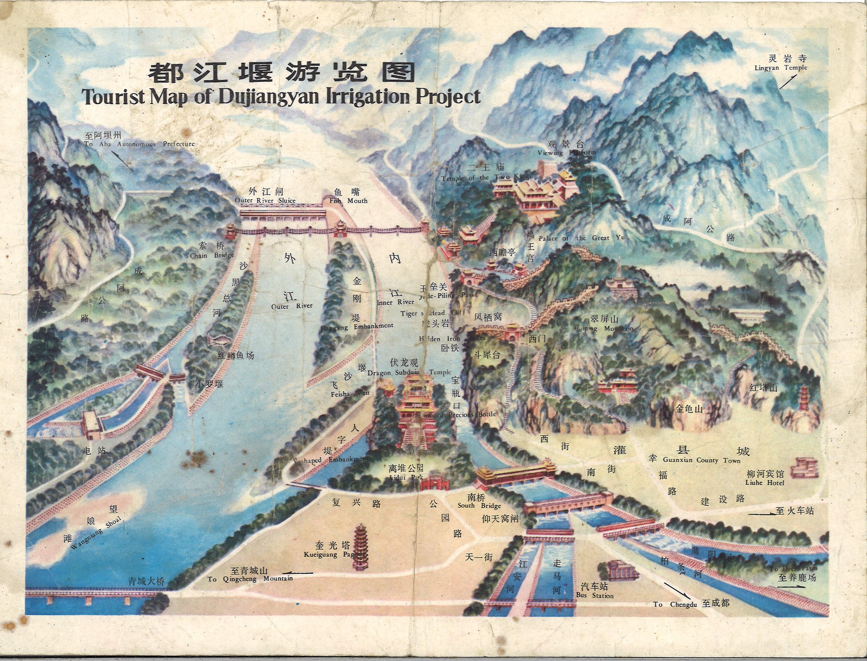
Who likes a map that can provide a source of geographic information? Does the satellite data map generated by various high-tech developments control the macro-geography to the micro-geography? Is the Tourist Map of Dujiangyan Irrigation Project a map? According to the spatial location marks of the Tourist Map of Dujiangyan Irrigation Project, as long as the tourists are willing to walk, everyone seems to be able to fully read the project and other related cultural products. And quickly gain a kind of self-confidence of knowledge from unfamiliar to understanding the project engineering. After several visits to Dujiangyan, combined with surveys outside the space of the Tourist Map, they found that the "dynamics" of the water system around the Dujiangyan Irrigation Project and its extremely complex geographic information were invisible. The mud and sand and the old driftwood as local metaphors seem to disappear in the blank area above the fish’s mouth that has not been indicated on the map. Without a map, can the governor still intervene in the Dujiangyan Irrigation Project in a modern way? |
The modernization of the Minjiang River system began with a hydropower dam with the help of the Soviet Union between 1958 and 1959. The dam was built not far from the upper Dujiangyan Irrigation Project, which was demolished before the flood season in 1961 because it was failed to tackle problems of floating woods and sediments. At the same time, the channels newly built or rebuilt in the 1950s included Sanhe Weir (also named Sanheyan), Renmin Canal, Dongfeng Canal, Jiefang Canal, etc. From the beginning of the Soviet Union Dam to the end of the Cold War, the imagination and practice of reforming the ecosystem in the politics of the nation-state have triggered some interrelated problems: What is left in the irrigation area of Dujiangyan today? What are the consequences of the development and technological advancement oriented by the reorganization of the water system?
In 2001, the Zipingpu Reservoir was built to ensure the accelerated development of the urbanization of Chengdu Plain and satisfied the need for water use, completely changing the water system of Dujiangyan. Under the new technological conditions of globalization, the Minjiang River, the water, and the surrounding complex geological environment have all appeared in the form of digital technology, and under controllable discussions and designs. On the surface, these water governances are only the milestone of Chengdu's modernization process, but actually, they are inseparable from the entire world. For example, the modern hydropower station technology that changes the ecology of the river basin separates local people from the environment and individual wisdom, and emotions no longer participate in the cycles of the traditional Dujiangyan water system and the local ecosystem. Factors that cannot be measured, such as knowledge and technological ideas in the Dujiangyan project, have gradually disappeared. Merely designing water as a calculable resource is a fascination with the modern technology paradigm. The original scale of the water system is limited to the perspective of the development of the nation-state.
The "Water System Project" attempts to build a new network of relationships among various systems in the local living environment. It explores the dynamic relationship in history between traditional hydraulic technology and modern technology. What are the continuous shaping and hidden impacts of the modern water system governance structure and the role played by water from the 1950s to the present in contemporary society? In the rheology of the water system across different geographical intervals and times, discuss the dialectical relationship between the wisdom of human habitation in nature and modern science. The project connects multiple power, and related disciplines participants to jointly face the ecological and social problems caused by changes in the water system.
The "Water System Project" is made up of multiple works, bringing together reflections on the upstream and downstream water systems of Dujiangyan. Through collaborative practices, installations, images, collected documents, and workshops, etc., It highlights the fixed narratives of water system reality, water system nationalism and anthropocentrism, rheology and damage of water systems, disasters of mountains, the individual practice of long-term planting and observation possibilities, refuges, and indigenous wisdom.
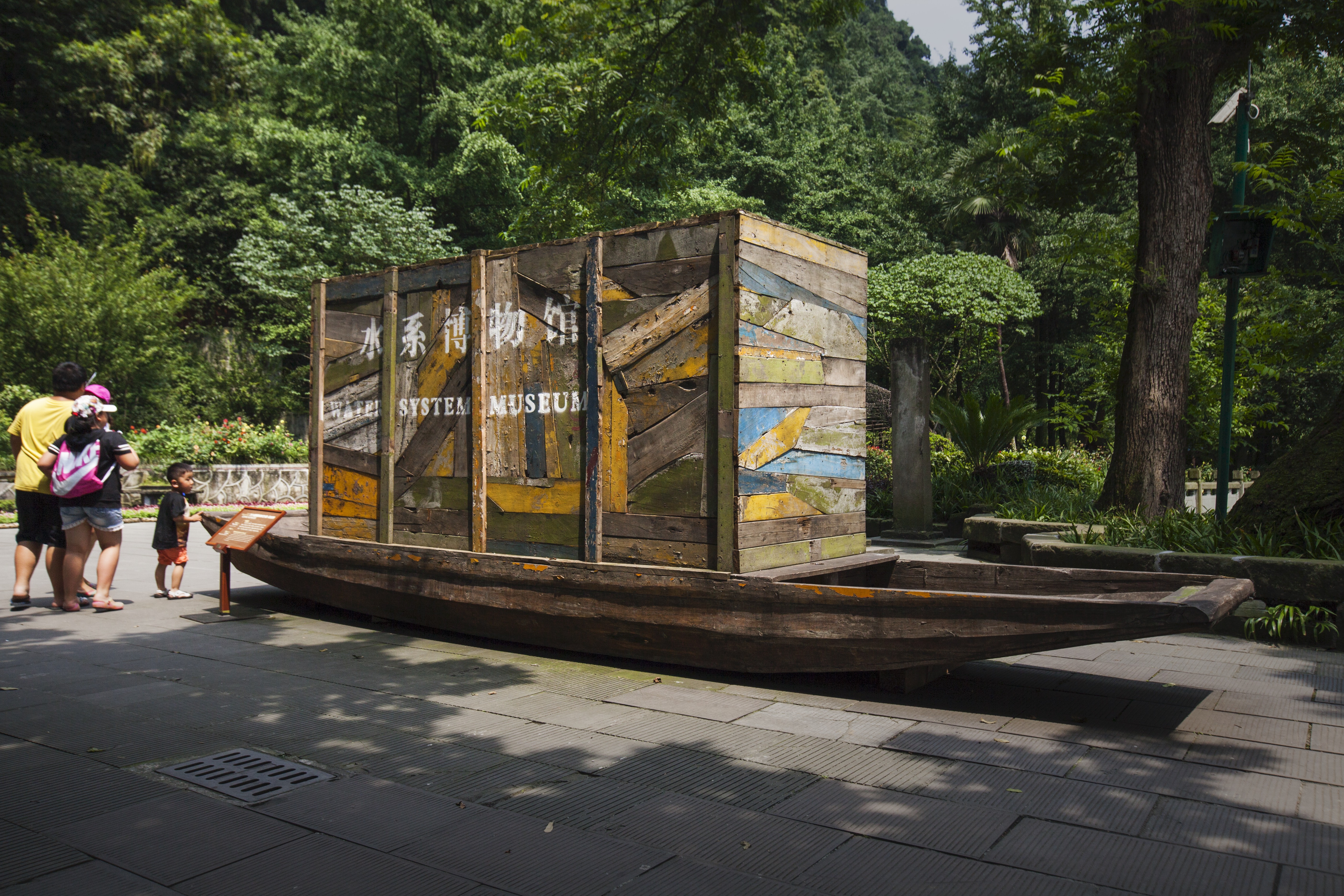
"Water System Museum" (on the banks of the lower Dujiangyan, Sichuan)
"Water System Museum"
Video | 19′28″ | 2015
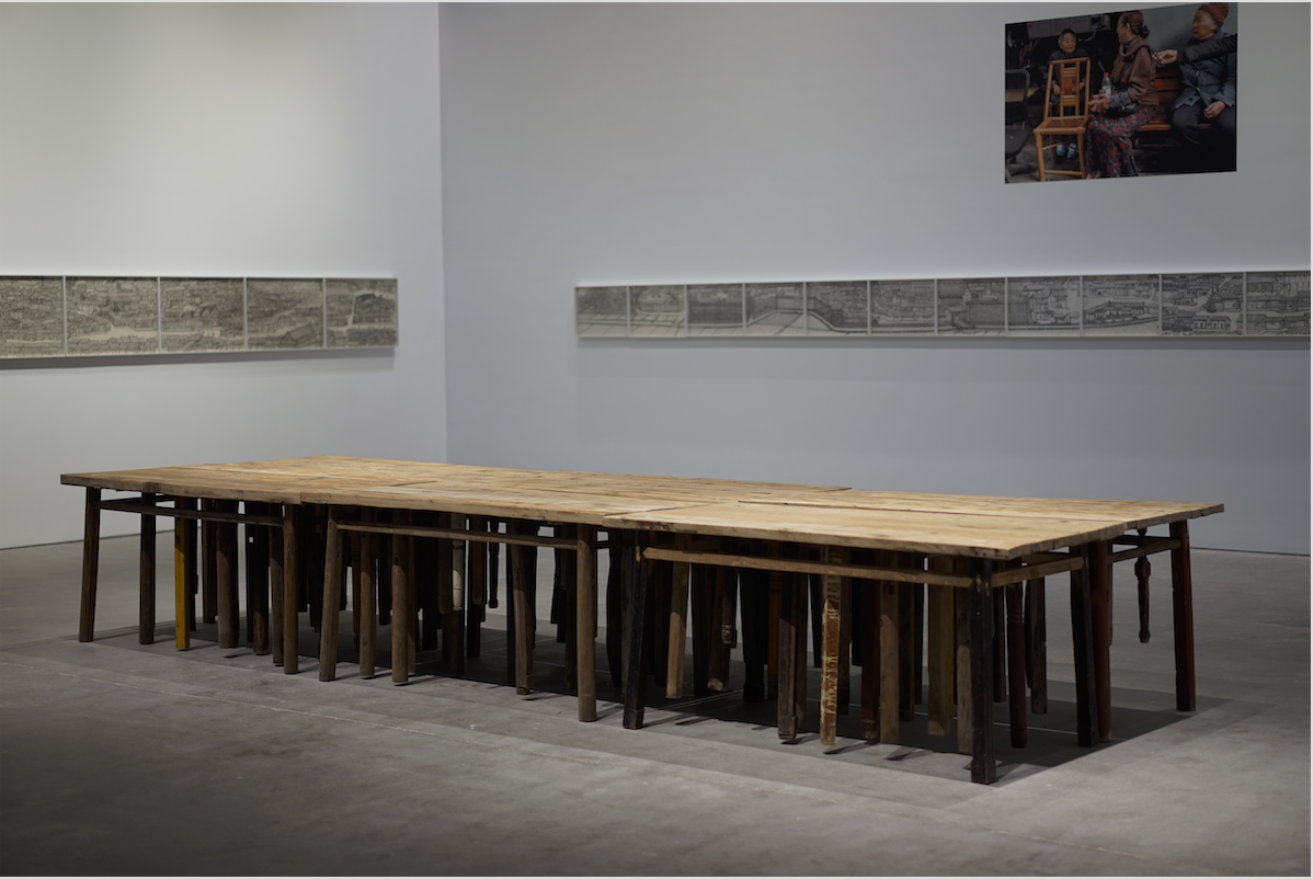
In a boathouse in Guangtan Village on the lower Dujiangyan, there was a ferryboat that was not sold and never launched, now it has become a "landscape" or an idle object. This change also constructs the relationship between the people living on both sides of the river and the water system. This idle ship evolves into the "carrier" for writing and forming a new place for dialogue by constructing a "Water System Museum" on this ship. In the early stage of creation, artists invited many shipbuilders to build the new shipbuilding workshop practices, from exchanging techniques, gatherings, tea shop exchanges, to ship-based production activities. Local shipbuilders participated in the project and cooperated with their shipbuilding techniques, using local wood and abandoned ships as basic materials to generate works, and tried to use the geographical characteristics of the water system to discuss the experiment of re-discovering the relationship between the water system and people. Artists established a transportation route for the "Water System Museum" in the dialogues between different locations, invited people living on both sides of the river to participate in the additional works of the "Water System Museum", and finally transported the "Water System Museum" to the exhibition site of Yulei Mountain in Dujiangyan. Due to insufficient water supply, the boat could not sail along the river, artists needed to sail on the land and pass through the working site in the fields, to conduct discussions about the reality of the water system and villagers' practices along the road.
 |
|
“Water System Museum" (on the banks of the lower Dujiangyan, Sichuan) |
 |
|
“Water System Museum" (on the banks of the lower Dujiangyan, Sichuan) |
 |
|
"Water System Museum" (on the banks of the lower Dujiangyan, Sichuan) |
 |
|
"Water System Museum" (on the banks of the lower Dujiangyan, Sichuan) |
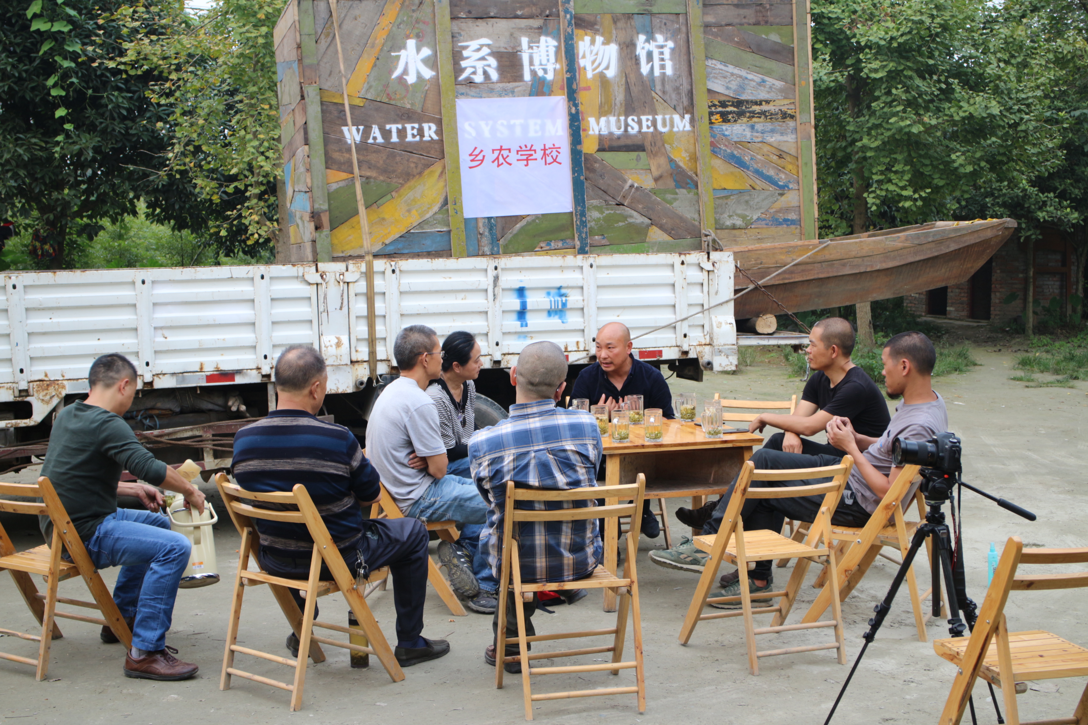
Along the trip of "Water System Museum" also includes the following practices:
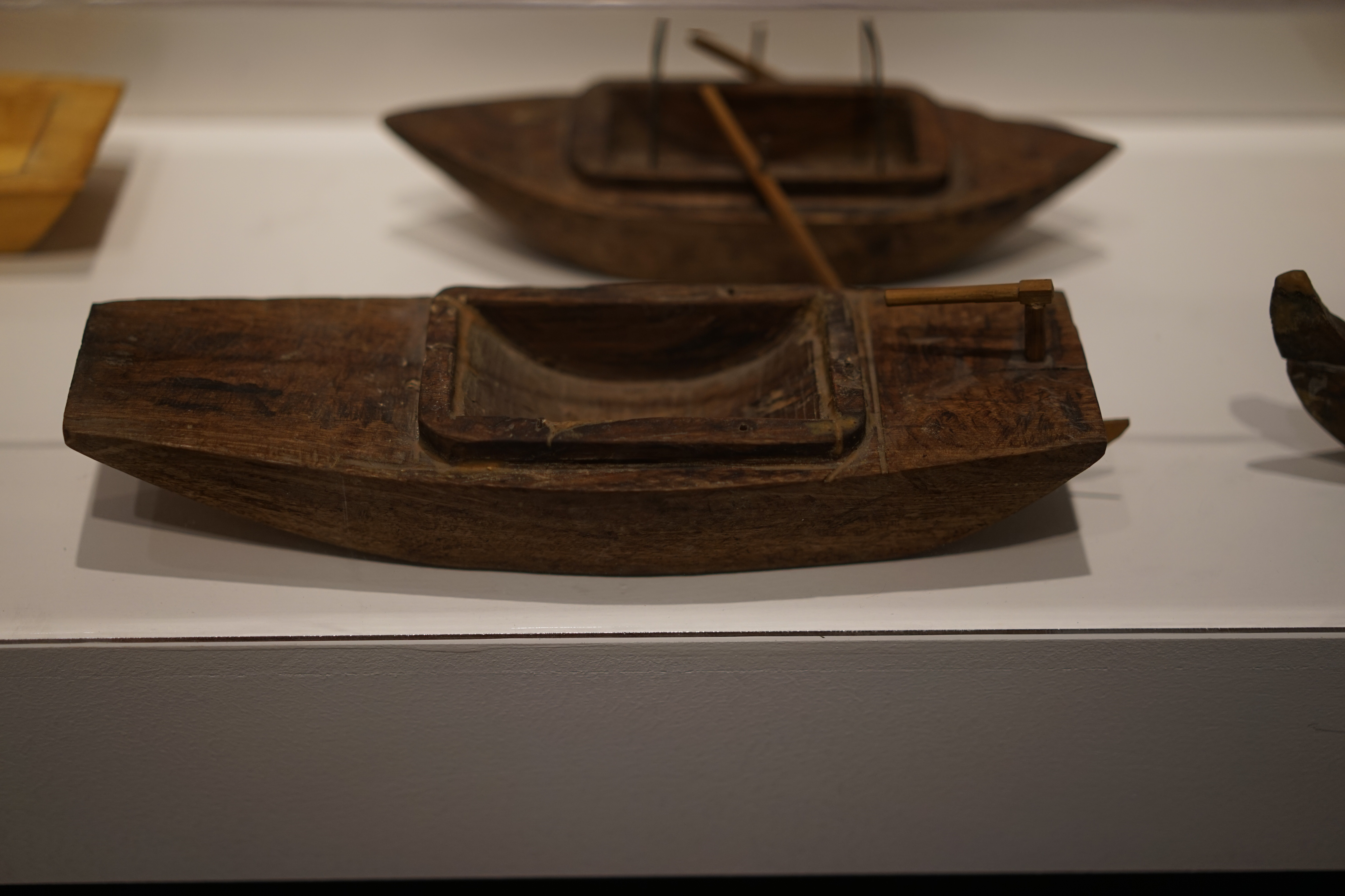
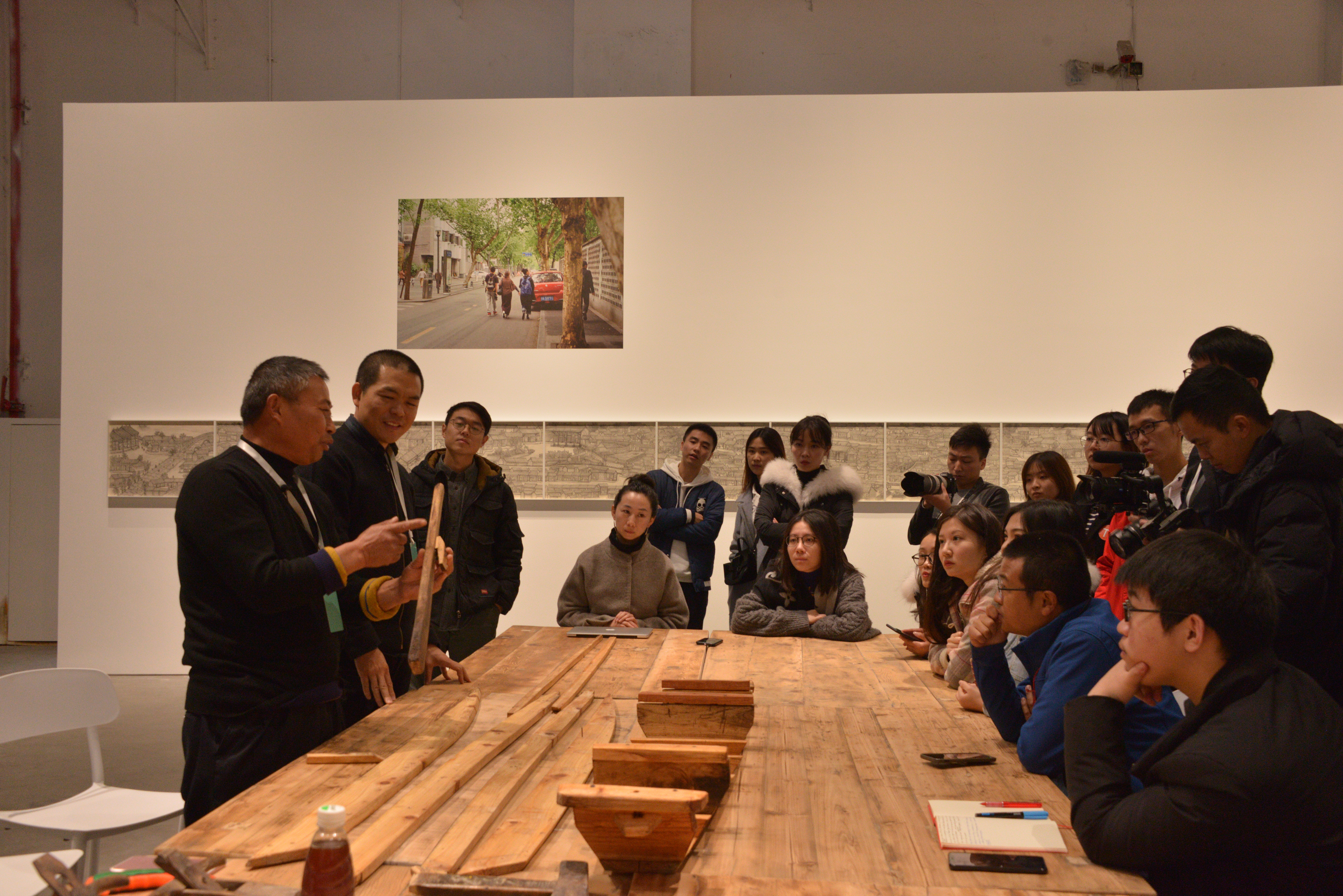
"A Shipbuilding Cooperation Workshop": Guangtan Village in Xinjin County is located in the transitional area of the Jinma River and Xihe River in the lower Dujiangyan. Because of the geographical environment of Guangtan Village, which "faces the water on three sides and the sky on the other", it has given birth to the well-known handcrafted shipbuilding industry. The Xinjin water transport ended in 1979, and the Nanhe pedestrian bridge opened in the summer of 2000, and the Xinjin ferry also ended. Inside Cheng's workshop are stacked wooden boats, sand transport boats, dragon boats, shipbuilding tools, and a ferryboat that has never been sold or launched. Through daily exchanges, gatherings, and tea shop exchanges, artists connected the villagers who have lost the skills of shipbuilding and farming, as well as those who are still building ships in other places, and people who buy ships, researchers, and protectors of intangible heritage, etc., forming "A Shipbuilding Cooperation Workshop". Meanwhile, artists cooperated with the shipbuilders to create the "Water System Museum" ship based on local timber and abandoned ships.
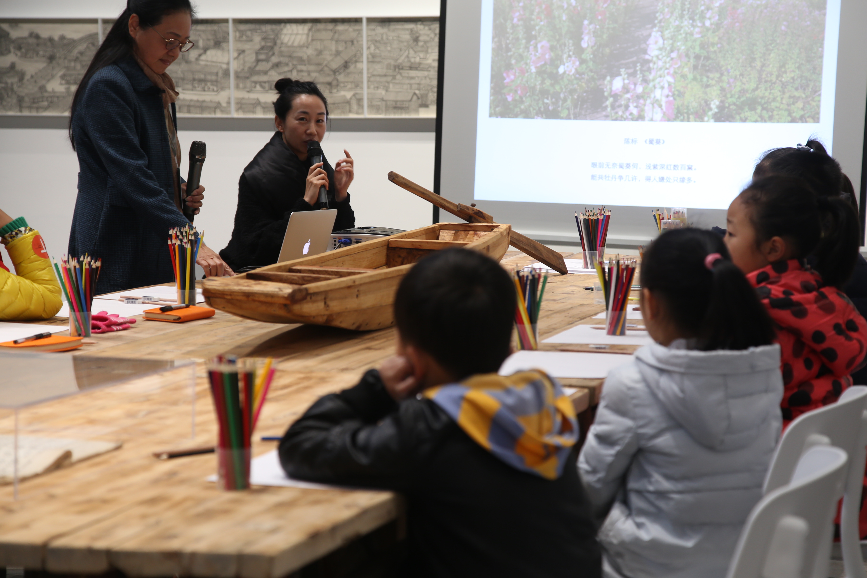
"Water and Well": Kunshan, which has been included in the new rural pilot area, has been in a state of transformation and change. For example, the wells in the village have been buried during land consolidation, and the relationship of "water" that connects people has also changed. In the resettlement area of the urban commercial district planning model, there are many natural villages, and the original Kunshan history and the relationship between people and land have almost disappeared. The picture "Water and Well Project——Cooperation and Revisiting Site" displayed on the Water System Museum includes “joint collaboration, mutual dialogue, temporary community, and revisiting site". This is an experiment conducted in a temporary status to see the village’s current situation after the community resettlement division.
"Named Dalangyan": At Liujiahao on the Jinma River, artists noticed that there was a ditch in the area. After searching the information, artists found that this ditch was called "Dalangyan", which was a drainage project during the Shunzhi period of the Qing dynasty. The "Dalangyan" was built by a monk named Da Lang, and after it was built, it was maintained through annual repairs. Chen Jianshi and Chen Yushu, the owner of Yushu Hotel, met artists by chance. After knowing about the story of the monk Da Lang and the "Water System Project", they hoped that their "Yushu Hotel" could participate in it. Yushu proposed to launch activities such as the reconstruction of the story about Dalang Weir, environmental discussions, and the launch of the "yan" festival in the hotel. At the same time, they renamed the hotel "Dalangyan" to discuss the possibility of the hotel as a group space in the local area.
"Village Farm School": This part of the work was carried out at the Gaojia Farm in Quanjia Heba. Artists learned the physical relationship between local villagers and local life, learned with the concept of "village farming school", accumulated local knowledge of local villagers’ life and production relations, and reproduced and built relationships with rivers, ditches, creatures, and the emotional connection of climate.
 |
 |
 |
 |
 |
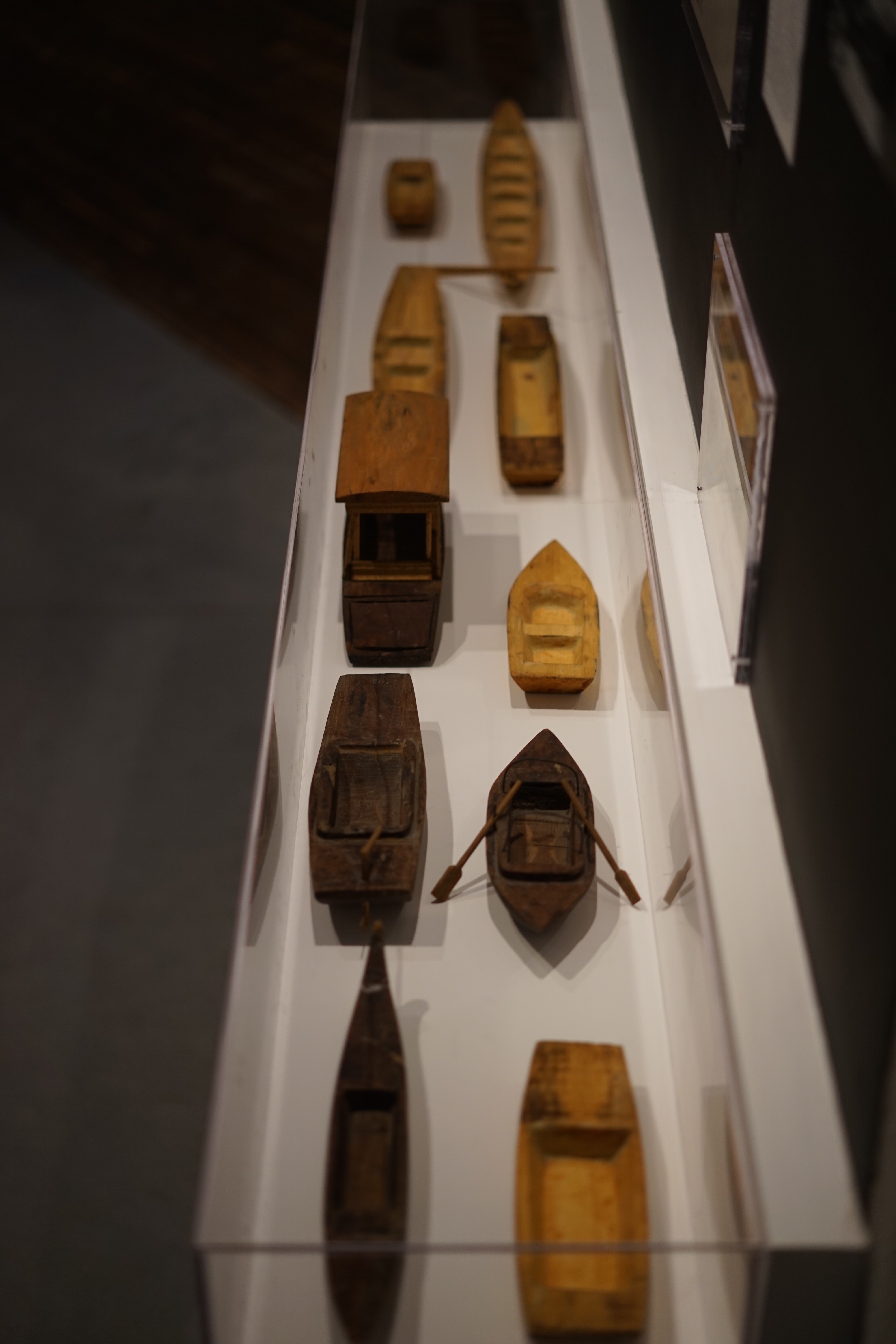
Ten water system objects
2017, wood, wire, china wood oil, glue, clay, paper
"After Re-Annotating a River" is based on the artists’ work on the Funan River Project, China’s earliest urban water system project, and uses methods such as city walks, interviews, photographic records, co-creation, and document display to exhibit the gallery’s space as a “social space”, it has been carried out under the framework of the 2018 International Art Biennale “Cosmopolis #1.5: Enlarged Intelligence in Collaboration with the Centre Pompidou Chengdu”. The project questions the complex relationship between the ecological environment and human society in contemporary cities and incorporates the artist's thinking on individual life experiences in urban renewal.
 |
|
"After Re-Annotating a River"(Chengdu downtown, Funan River, the lower Dujiangyan, Sichuan) |
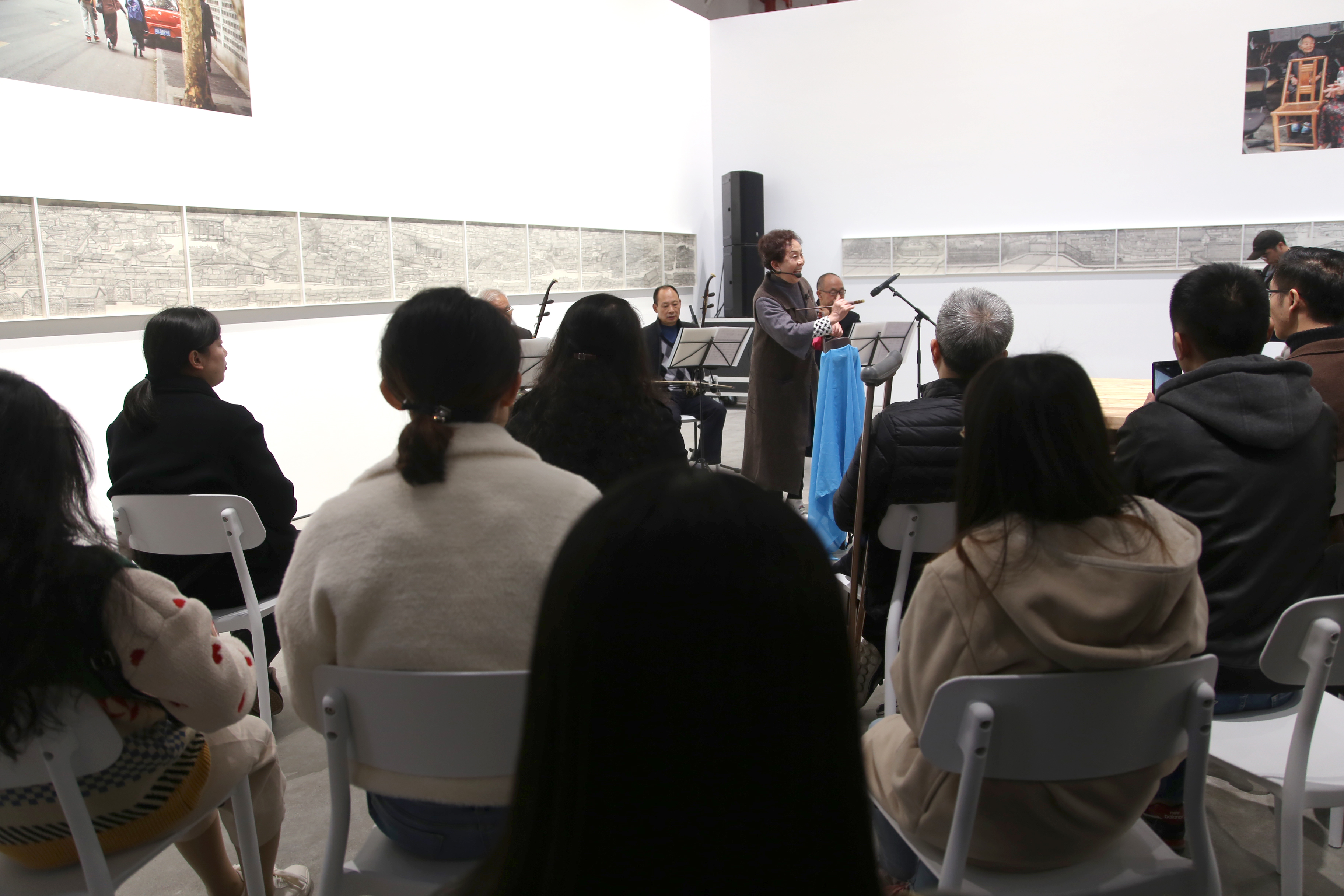
Artists planned six workshop meetings based on research on urban water system governance decisions, space design, and individual family life placement. In the "Qingyin performance", Ms. Gong Suqing sang the bits and pieces of past life in the market in front of the paintings, connecting different dimensions of memory and opening up the water system's geographical space from time. In the "Shipbuilding Craftsmanship" section, Master Cheng taught shipbuilding skills, focusing on the history of changes in Guangtan Village's shipbuilders and river water transportation and water systems, as well as the imagination of technology and river networks. The "Picture Book Annotation of River Stories" workshop was hosted by the artists and the supervisor of the Chengdu Urban River Research Association, and hosted by Hua Hua of "Chengdu River Story' ', the participants are children. This picture book is created with the story background of Fuhe, Nanhe, and Shahe depicts the understanding and imagination of the river beyond the adult voice. "Artistic Intelligence as Universe Technology '' invited anthropologist Ren Hai to share the concept of "artistic intelligence", thinking about how art allows us to deal with various challenges in a de-anthropocentric "cosmic city". "How do we live'' was hosted by Xue Liang of Changmin Architecture Studio, leading participants to design and create, thinking about the relationship between architecture and social space imagination, ecological geography, terrain, and terroir, and reflecting on the urban architecture that is too singular in residential function and planning. In the "People, Antarctica, Garbage" workshop, scientist Zhang Xuehua shared her research on urban solid waste management and other aspects and invited the audience to participate in ecological and environmental technology ideas. Zhang Xuehua proposed the possibility of changing individual consciousness and behavior from understanding the source of rubbish.
 |
|
"After Re-Annotating a River"(Chengdu downtown, Funan River, the lower Dujiangyan, Sichuan) |
 |
|
"After Re-Annotating a River"(Chengdu downtown, Funan River, the lower Dujiangyan, Sichuan) |
 |
|
"After Re-Annotating a River"(Chengdu downtown, Funan River, the lower Dujiangyan, Sichuan) |
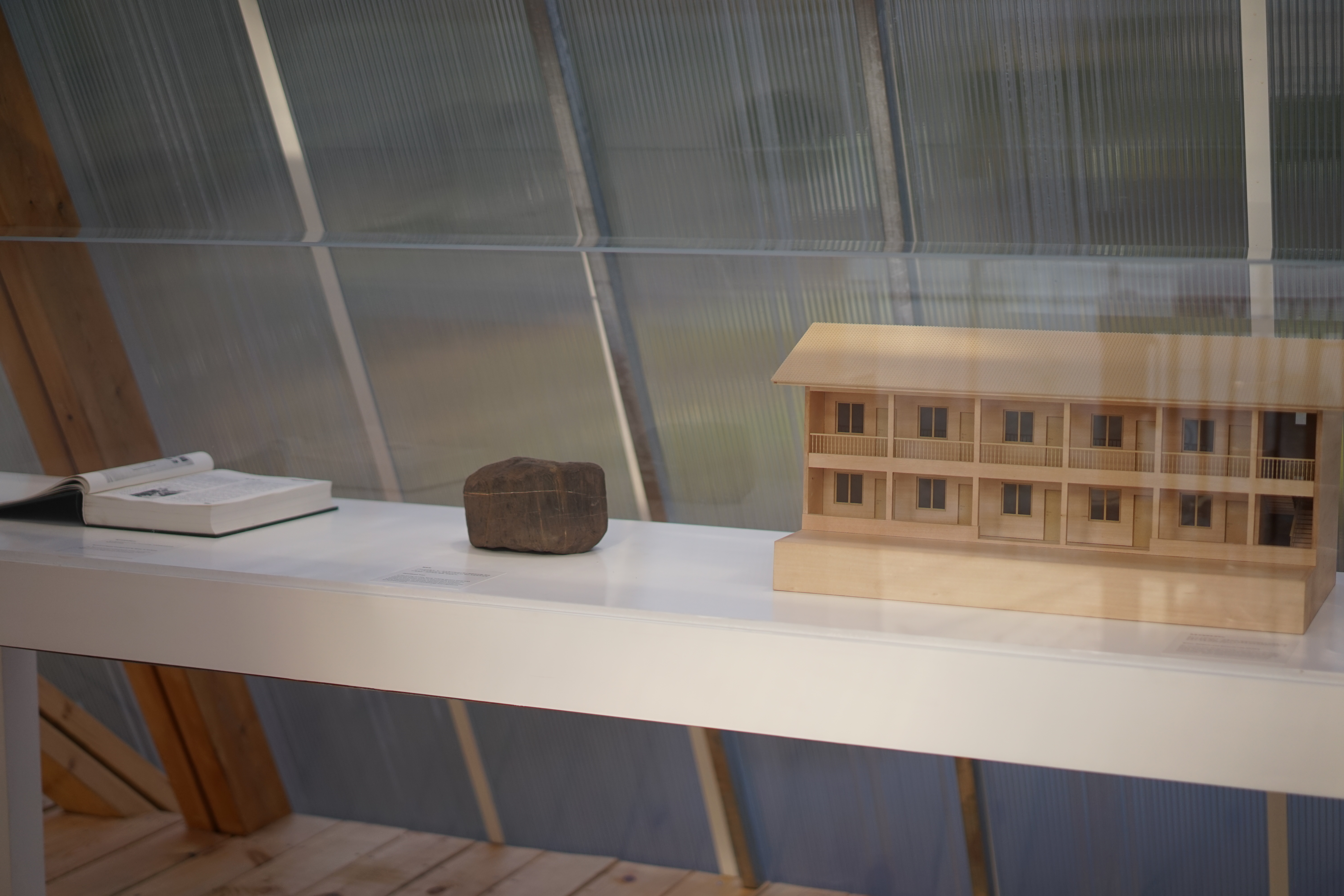
In and around the hometown of Wang Yizhong, a farmer from Shuitianping Village in the upper Dujiangyan, the problems of forestry logging, mining and deforestation began to appear in the 1950s. He has been planting trees on barren hills for over 20 years. He has planted nearly 80,000 plants and carried out long-term water measurement records at the same time. The artists cooperated with Wang Yizhong's family to transform the hotel Ziping Homeland, which has been in a semi-idle state for a long time, to connect with local ecological practices and named it the "Water System and Natural Life Center".
In "On the Edge of Mountains and Rivers", the artists juxtapose the "edge" of the mountain water imagery in Chinese culture with the connection and tension between urban development and the natural environment using images, documents, and object evidence, to tell the evolution of ecological history. The installation was exhibited at the International Art Biennale of "Cosmopolis #1.5: Enlarged Intelligence in Collaboration with the Centre Pompidou Chengdu".
 |
|
"The Edge of Mountains and Rivers" (Shuitianping Village, Upper Dujiangyan, Sichuan) |
 |
|
"The Edge of Mountains and Rivers" (Shuitianping Village, Upper Dujiangyan, Sichuan)
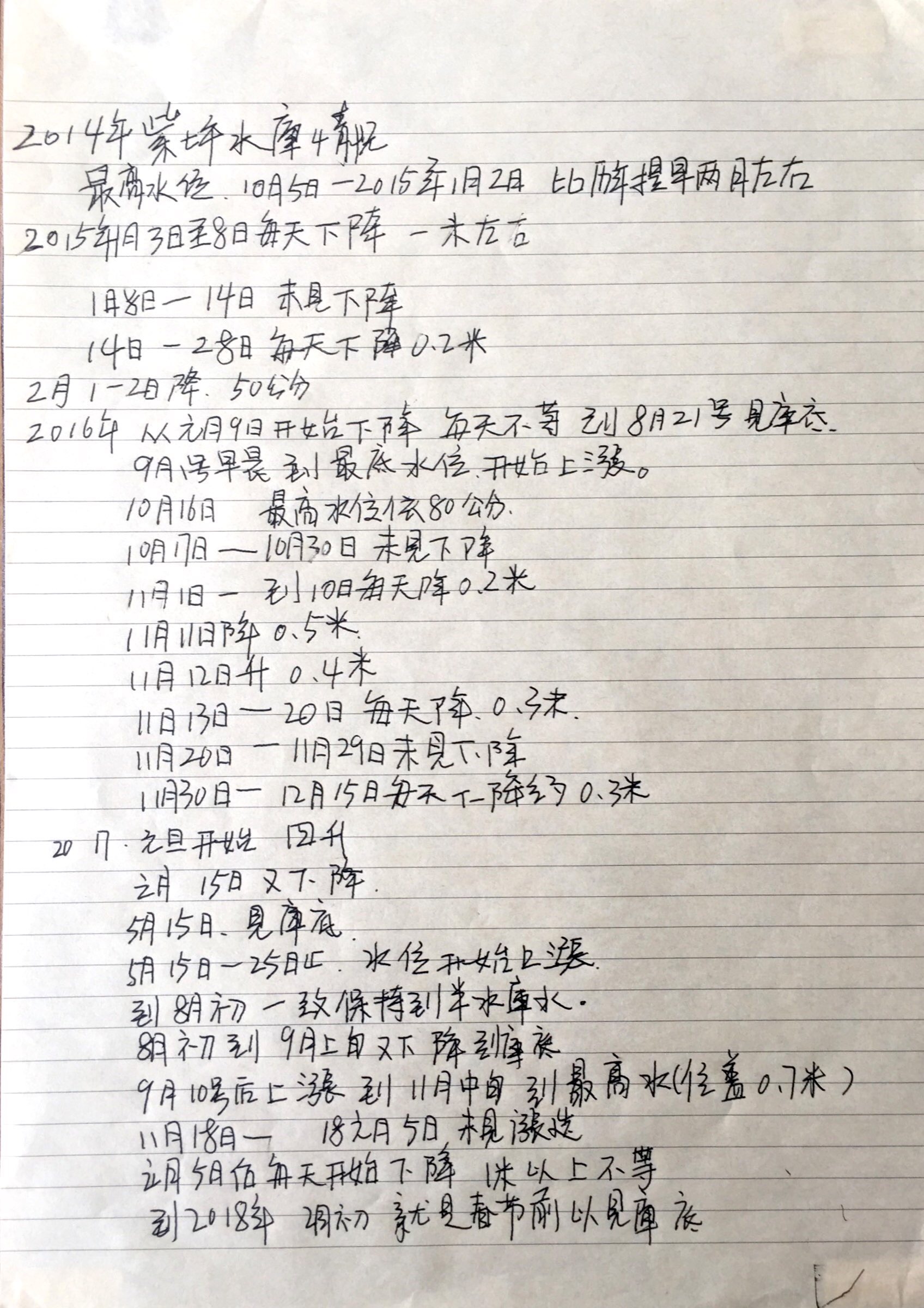
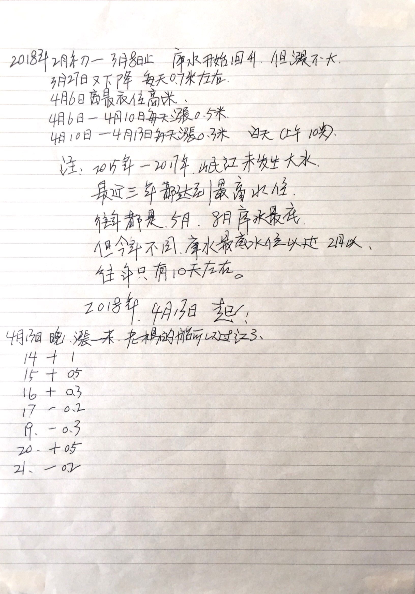
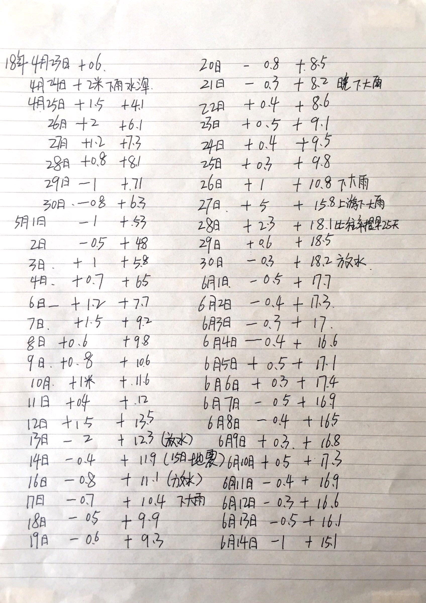
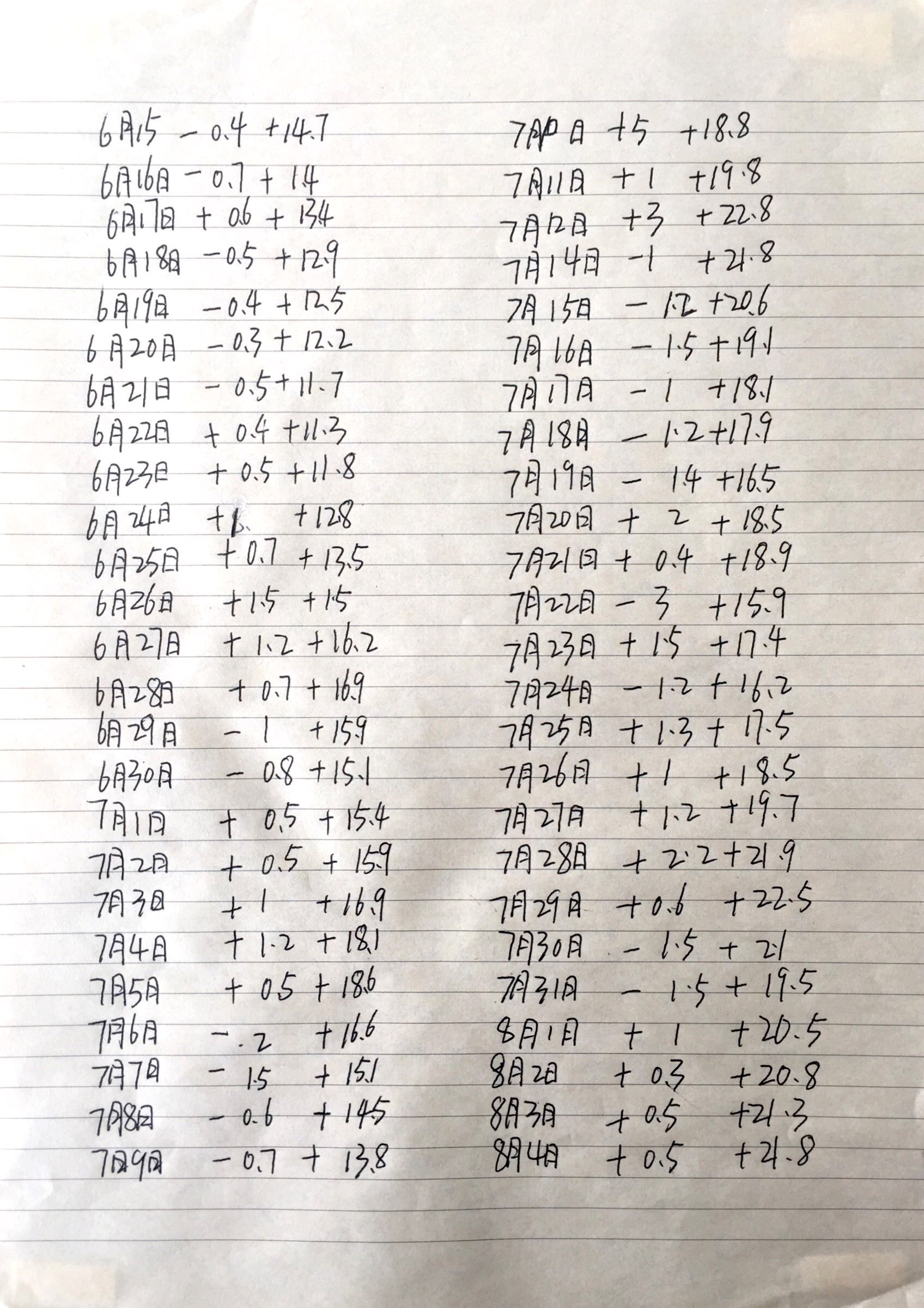
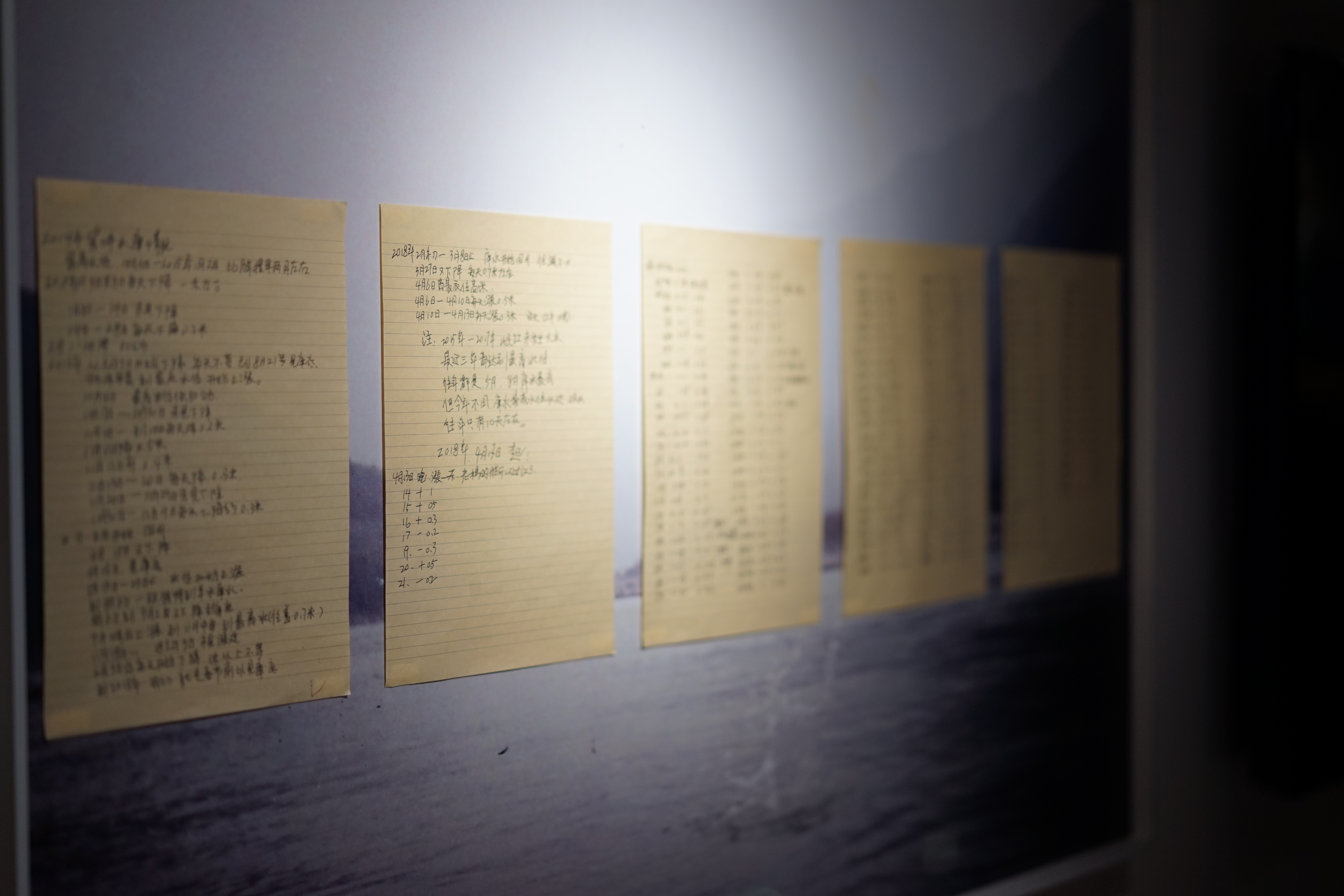
"Water Measurement Notes" |
 |
|
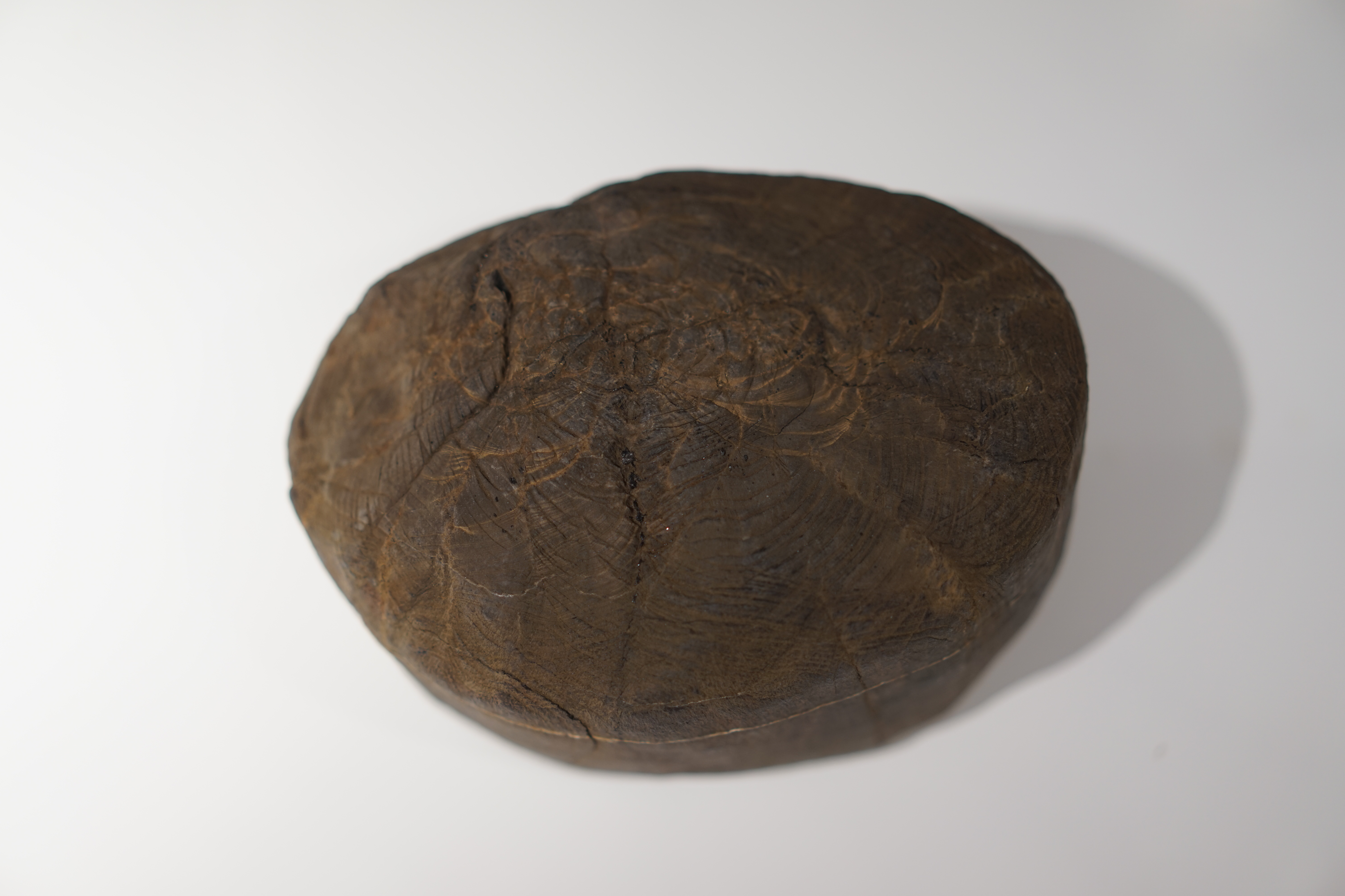
"The Edge of Mountains and Rivers" (Shuitianping Village, Upper Dujiangyan, Sichuan) In the spring of 1999, while planting trees on the hillside opposite his home, Wang Yizhong found a stone, with tree ring-like patterns on its surface. He believed that this stone could clarify the geology and vegetation in this area, and it has been preserved. |
 |
|
"The Edge of Mountains and Rivers" (Shuitianping Village, Upper Dujiangyan, Sichuan) |
 |
|
"The Edge of Mountains and Rivers" (Shuitianping Village, Upper Dujiangyan, Sichuan) |
 |
|
"The Edge of Mountains and Rivers" (Shuitianping Village, Upper Dujiangyan, Sichuan) |
"Observing point"
Video | 17′30″ | 2019
"After excessive deforestation from the upper river,
I began to plant trees in 1998.
The first one, the second one, the third one...
Later, more people joined.
After 21 years, a total of 74,912 trees have been planted.
Gradually, many new plants started to grow in the forest..."
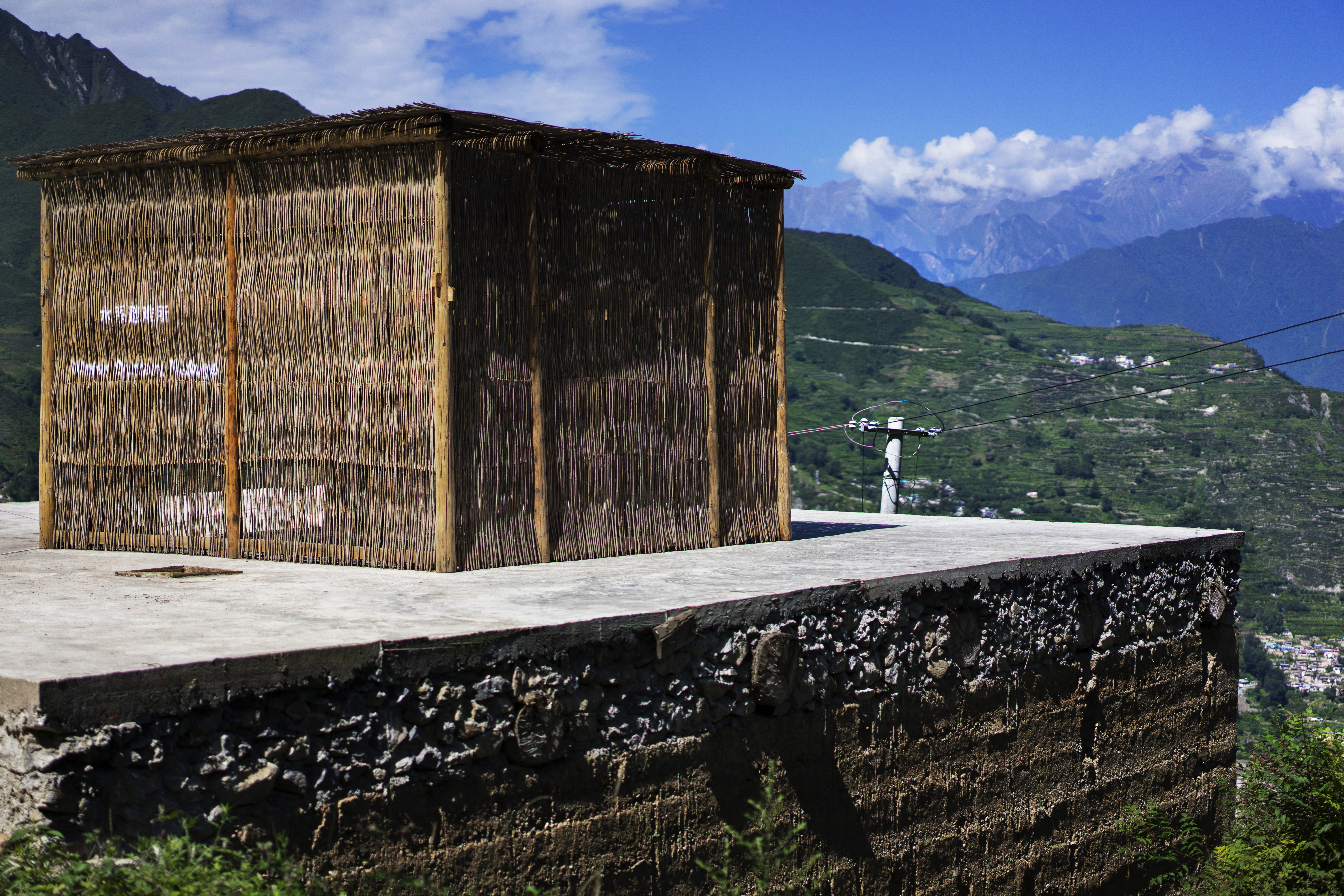
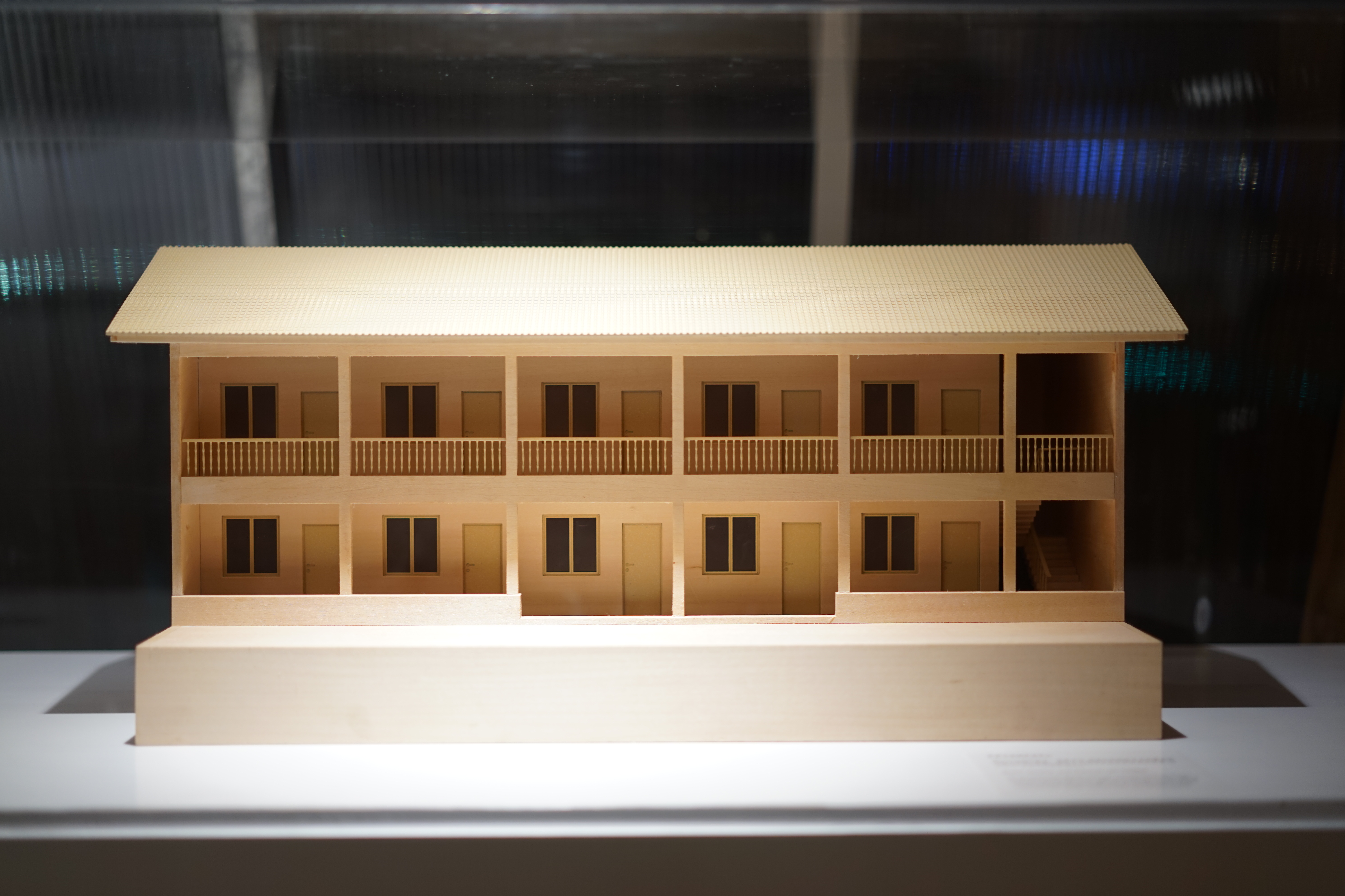
"Water System Refuge"
Video | 17′30″ | 2019
"... In the legend, there were three holy streams: Yanmen River, Wenzhen River, and Qipan River.
The three rivers are called three sisters by the locals.
Yanmen River, the second sister, has the worst temper.
After the arrival of the hydropower dam, sand factory, and earthquake,
Yanmen River became more irritable.
I came with my big brother,
to perform sheep-skin drum dance (The traditional dance performed by Qiang people) to my Yanmen River,
the second sister."
"Observing Point" and "Water System Refuge" are the two ongoing artistic research in the upper Minjiang River and Dujiangyan. Through cooperation with local residents and researchers, they have discussed small-scale practices to integrate landscape, ecological, climate change, and alternative future issues. It also paid attention to the impact of government policies and post-disaster reconstruction after the Sichuan earthquake in 2008.
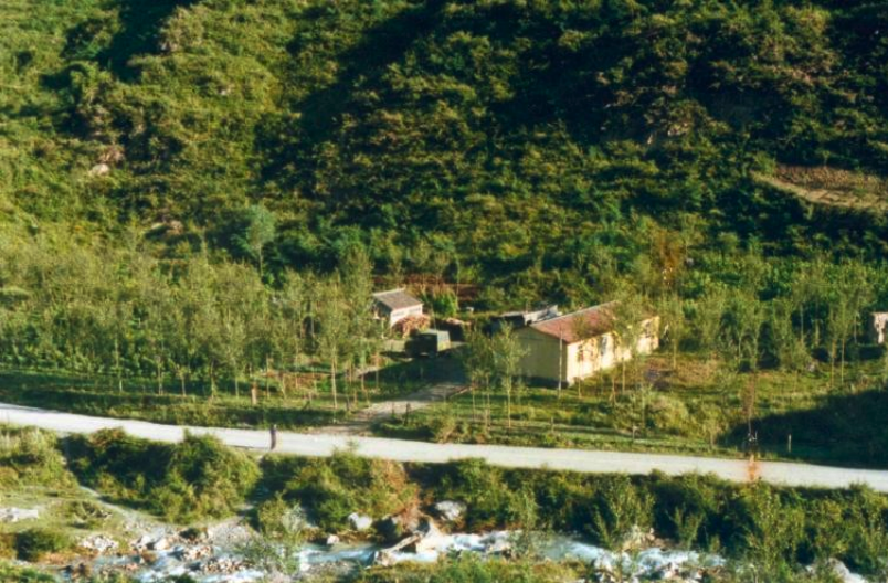
The background of this work was that from 1958 to 1959, a hydropower dam supported by the former Soviet Union was built near the upper section of the Dujiangyan irrigation project. Because the dam failed to tackle problems of floating wood and sand, it was demolished before the flood season in 1961. The relics of the plant stand next to the Dujiangyan irrigation project and since then, it has been a barren wasteland.
After the Wenchuan earthquake on May 12th, 2008, the hidden reality surrounding the water system of the Minjiang River system re-emerged, after having long-term immersion in the sense of instrumental rationality and technology. The relics of the Soviet power plant represent a water conservancy machine with an adventurous spirit, a forgotten space reshaping the ideology of local shanshui (mountain and water) topography. It is a failed project in the history of modern technology. And it brings us back to the discussion of contemporary river issues.
 |
|
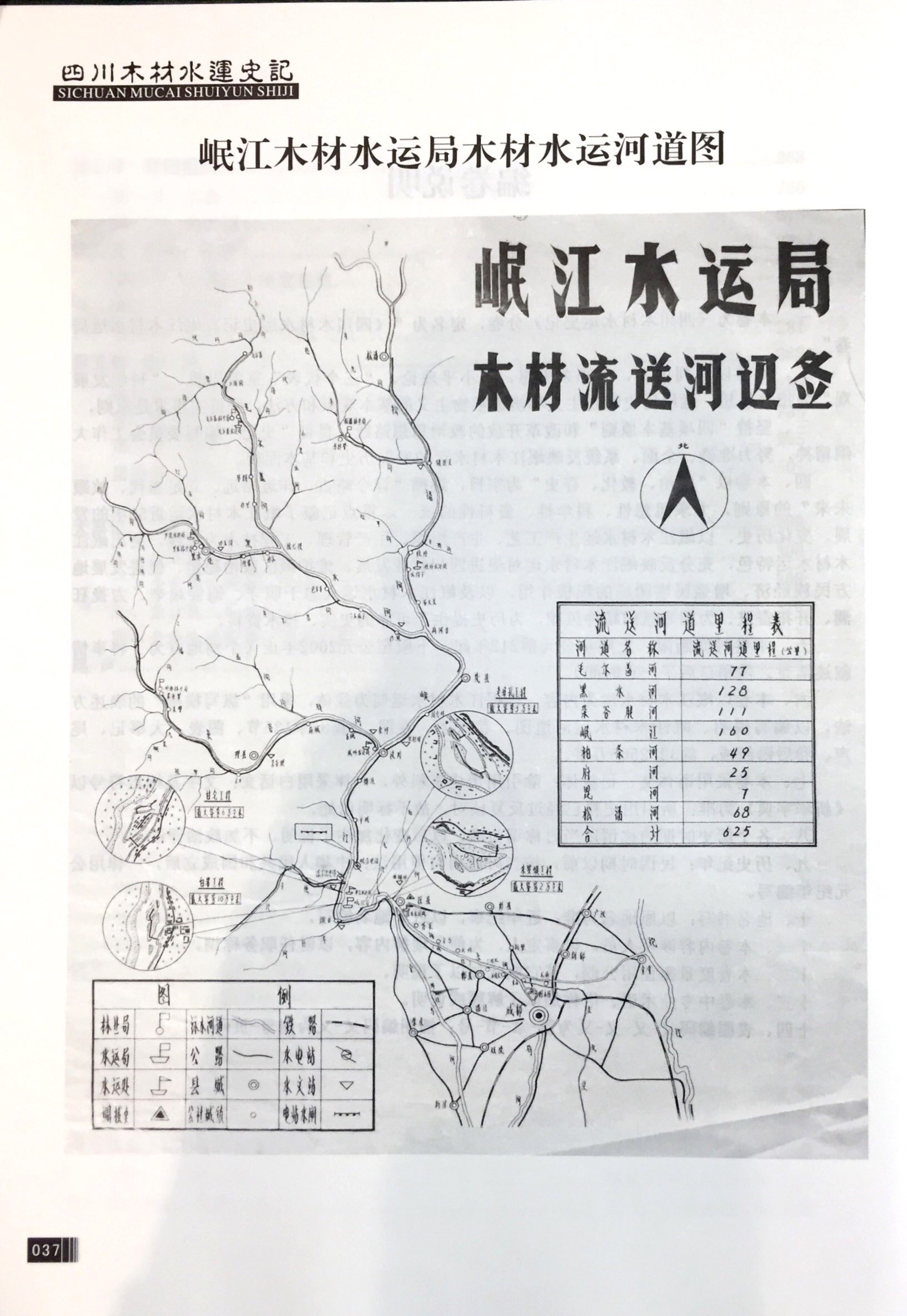
Maoxian Mountain Ecosystem Positioning Research Station 1987, has long been concerned about the ecology and biodiversity of the mountain system in the upper Minjiang River. (Picture provided by Chen Qingheng, a biologist)
|
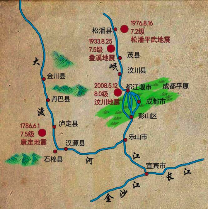 |
|
(A sketch Map of the Minjiang River system, drawn by geologist Fan Xiao) |
The video "Water System Refuge" (2019) attempts to extend the relationship between disaster history and the present in a dynamic way. In remote Qiang villages in high mountains and valleys, they found the traditional Qiang houses built by Quanzhai after the earthquake. This kind of building once again connected the interaction of the entire village and the local materials but beyond the standard of the dominant "Modern ecological technology" after the earthquake. So they used local post-earthquake waste wood and together with participants from the Qiang ethnic group to build a "water system refuge" space installation that cannot withstand the wind and rain and placed it on top of the building constructed by local traditional techniques. In the space, they also thought about the possibility of sustainable living with the participants and discussed plum planting as an economic policy for reconstruction, although plum planting has created a growing market for the local area, it also threatens sustainable traditional agriculture. The Qiang language that accompanies farming and construction activities is also facing decline.
At the hydraulic project site, it is impossible to see this kind of change, only the replacement of specific engineering materials can be seen. As the main body of the water system, the Dujiangyan Project has evolved into an outdated abstract performance device based on the logic of urbanization development, and it has nothing to do with the reorganization of upstream and downstream systems under the operation of capital and authority. The long-term work allowed them to travel back and forth between the various systems of Dujiangyan’s local living environment to discuss the many unexplained "what has appeared" and “what has disappeared” around this water body (the construction of Dujiangyan). This may be the formation of a new method of cognition that is not based on hydraulic mechanisms, empirical scientific authorities, and development logics, and can be extended to all things and all possibilities in the future.
(Information and text are provided by the artists, edited by the project team. All rights reserved.)